Details
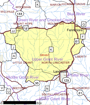
The Upper Grant River Watershed is a 106 square mile watershed in west central Grant County. It is on the south slope of Military Ridge. The topography of the watershed is typical of the driftless region and ridges are narrow to broad with steep slopes that lead down to narrow valley floors that widen downstream. As a result, runoff of melt and stormwater is rapid, increasing the erosive potential of the runoff. The water quality and instream habitat problems in the watershed are directly related to this rapid runoff from barnyards and cultivated farm fields. Both excessive sediment and nutrient loading is affecting instream habitat and may be responsible for other water quality problems (Fix, 1998,1991)
There are 84 miles of streams in the watershed. The Upper Grant River watershed has the greatest amount of coldwater stream miles in the Grant-Platte basin with over 33 stream miles being classified as coldwater streams. Approximately 20 stream miles are classified as either warmwater sport fishery or warmwater forage fishery. Martin Branch and Rogers Branch are both listed as impaired waters as a result of non-point source pollution. The streams and the watershed as a whole have been ranked as a high priority with respect to non-point source pollution. The groundwater in the watershed has a high potential for contamination as a result of non-point source pollution.
Date 2001
Population, Land Use
Agriculture is the dominant land use and primary economic engine in the watershed. Over 83% of the land area in the watershed is cultivated or in pasture. Croplands in the watershed have been estimated to have an average annual soil loss of 7.6 tons per acre per year (Midwest Reclamation Planners, no date). There are fewer but larger farms and an overall trend toward a greater concentration of animals in the watershed.
Although agriculture is the dominant land use, there are three communities within the watersheds boundaries: the Village of Mount Hope (174), the City of Fennimore (2,650), and the unincorporated community of Stitzer. Each of these municipalities have a wastewater treatment plant that discharges to surface waters in the watershed.
Despite the generally slow rate of growth in southwestern Wisconsin, the population of Fennimore has grown by about 11% since 1990. This growth rate is faster than the state average during the same timespan. Due to its location on top of Military Ridge and in the headwaters of three coldwater streams, Gregory Branch, Rogers Branch and Fennimore Fork (Lower Wisconsin Basin), without careful planning, sources of non-point pollution from the city have the potential to negatively impact these water resources. Documentation from around Wisconsin and the country has shown that sediment from construction sites and increased stormwater flow from developing areas can adversely affect water quality, fisheries and instream habitat. Fennimore will need to address these erosion control and stormwater management issues as it continues to grow.
Date 2001

Ecological Landscapes
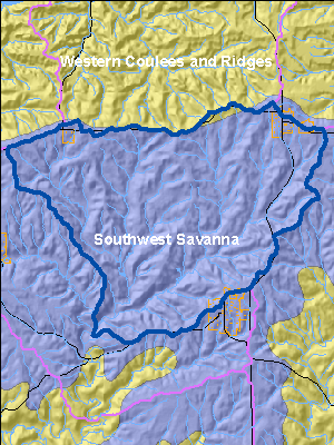
The Upper Grant River Watershed is primarily located in the Southwest Savanna Ecological Landscape which is found in the far southwestern part of the state. It is characterized by deeply dissected topography, unglaciated for the last 2.4 million years, with broad open hilltops and river valleys, and steep wooded slopes. The climate is favorable for agriculture but the steep slopes limit it to the hilltops and valley bottoms. Soils are underlain with calcareous bedrock. Soils on hilltops are silty loams, sometimes of shallow depth over exposed bedrock and stony red clay subsoil. Some valley soils are alluvial sands, loams, and peats. Some hilltops are almost treeless due to the thin soil while others have a deep silt loam cap.
Historic vegetation consisted of tall prairie grasses and forbs with oak savannas and some wooded slopes of oak. Almost three-quarters of the current vegetation is agricultural crops with lesser amounts of grasslands, barrens, and urban areas. The major forest types are oak-hickory and maple-basswood. High-quality prairie remnants occur on rocky hilltops and slopes that are not farmed. Some prairie pastures and oak savannas still exist. The grassland areas harbor many rare grassland birds, invertebrates, and other grassland species. Relict stands of pine occur on bedrock outcroppings along some stream systems.
Date 2010
Recreational Opportunities
Public recreational activities in the watershed are limited and fishing is the most accessible recreational opportunity. Until 1995, except for several state owned public easements along the Little Grant River, Martin Branch and Rogers Branch, the Borah Creek Fishery Area was the main public land for recreation in the watershed.
In 1995, the City of Lancaster received a small grant to improve the 14.5 acre Klondike Park which lies along the Grant River just off of County Highway K. The grant provided funds to construct a walking trail, improve the restroom, and purchase some accessible picnic tables. The City of Lancaster has some plans for future improvements which would include improving the fishing area and stabilizing the shoreline along the river.
Hunting on private lands is allowed with the permission of the property owner. There is good wildlife habitat, including in woodlots on the steeper slopes, in many parts of the watershed. Additional habitat could be provided if additional lands were enrolled in the CRP and CREP programs.
Date 2001
Monitoring & ProjectsProjects including grants, restoration work and studies shown below have occurred in this watershed. Click the links below to read through the text. While these are not an exhaustive list of activities, they provide insight into the management activities happening in this watershed.
Watershed Recommendations
Date
Status
Conduct basin assessment monitoring in the Upper Grant River Watershed- Little Grant River, Grant River, Borah Creek, Gregory Branch, Rogers Branch, Martin Branch and Day Branch.
1/1/2010
Proposed
Snowden (Big Patch) Branch TMDL
Date
Status
The sediment TMDL was approved September 12, 2006.
5/1/2010
In Progress
Castle Rock & Gunderson Creek TMDL
Date
Status
The Castle Rock and Gunderson Creek TMDL was created to address phosphorus, sediment, and for at least one creek biological oxygen demand. The TMDL was approved and is in implementation through projects funded by the Clean Water Act Section 319 Program.
6/28/2004
In Progress
 Watershed History Note
The City of Fennimore is located in the northeast corner of the Upper Grant River watershed in Grant County. The Fennimore library collection dates back to 1849, when it was housed in a room at the Methodist Church and then at the Old Fennimore House.
In 1922, Fennimore banker, Dwight T. Parker, donated the sum of $35,000 for the construction of a library on an "adequate site" for "focus as one of the beautiful points of interest in the City of Fennimore." Upon his death in 1934, Parker's will added a $10,000 trust fund dedicated to the operation of the library. After depletion of the trust fund, Fennimore assumed the library's total cost of operation.
The Dwight T. Parker Public Library in Fennimore, Wisconsin represents an excellent example of the small-scale library construction. Madison, Wisconsin architects Louis Ward Claude and Edward F. Starck incorporated an Italianate theme into the design of the Fennimore library, completed in 1924.
The red brick two-story rectangular building with wide overhanging eaves features a hipped red clay tile roof with a single brick chimney rising through the southeast slope of the roof in the rear of the building. The pedimented frontispiece and coping on the projecting entry are terra cotta. Two sets of three round-headed windows flank each side of the entryway and are adorned with terra cotta colonettes and bracketed sills. Inside, oak moldings and furnishings give a warm feel to the library as does a tile fireplace.
Date 2010